Frequently asked questions
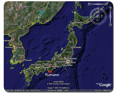
- Where's Kumano?
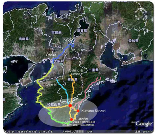
Kumano is the ancient name for the southern part of the Kii Peninsula. This peninsula, located south of Osaka, Kyoto and Nara, is the largest in Japan. It is a spiritual hot spot containing Ise-jingu shrine, Yoshino & Omine, Koyasan and the sacred Kumano Sanzan Shrines. There is no official Kumano region today. This name dates back to prehistoric times and for the Japanese conveys a deep sense of mystery and awe. Kumano is associated not only with Yomi-no-Kuni, the mythical land of the dead, but also Buddhist celestial paradises.
Kumano Kodo
- How do I break up the distance (25 km) between Chikatsuyu and Kumano Hongu Taisha?
Many guests will take an early bus from the Chikatsuyu area (Chikatsuyu-oji or Nakahechi Art Museum parking lot) or Nonaka/Tsugizakura (Nonaka Ipposugi bus stop) to cut the long distance to Hongu and thereby maximize their time at Kumano Hongu Taisha and arrive on time for dinner at their nearby accommodation.
Walking Options
Full Walk
Chikatsuyu-oji to Kumano Hongu Taisha ~25 km, 9-12 hours
Tsugizakura-oji to Kumano Hongu Taisha ~21.5 km, 8-11 hoursIntermediate Walk (use local bus)
Kobiro-toge bus stop to Kumano Hongu Taisha ~19 km, 7-10 hours
Doyukawa-bashi bus stop to Kumano Hongu Taisha ~17 km, 6-9 hoursHighlight Walk (use local bus)
Hosshinmon-oji to Kumano Hongu Taisha ~7.5 km, 2-3 hours
For those staying at Yunomine Onsen you can add the Dainichi-goe ~2 km, 1-2 hoursWalking Options are also listed on the right side of this Tsugizakura to Hosshinmon-oji section map including bus stops to shorten the distance.
Where’s Kumano?Kumano is the ancient name for the southern part of the Kii Peninsula. This peninsula, located south of Osaka, Kyoto and Nara, is the largest in Japan. It is a spiritual hot spot containing Ise-jingu shrine, Yoshino & Omine, Koyasan and the sacred Kumano Sanzan Shrines. There is no official Kumano region today. This name dates back to prehistoric times and for the Japanese conveys a deep sense of mystery and awe. Kumano is associated not only with Yomi-no-Kuni, the mythical land of the dead, but also Buddhist celestial paradises.
What’s the weather like?The climate in the Kumano is temperate, especially along the coastal areas. Once you get into the mountains weather can change quickly. It rarely snows in the southern portion of Wakayama prefecture.
more Weather >>Are there any downloadable maps or pamphlets for the area?Yes, we have many maps and pamphlets that are downloadble in PDF format. Maps include Japanese characters to make them user friendly when navigating the area.
more maps & pamphlets >>What’s an Oji?Ojis are shrines along the Kumano Kodo pilgrimage route. They served as sites of worship, ritual and rest and are an integral part of the pilgrimage to Kumano.
more Oji >>I have questions about the DUAL PILGRIM initiative, where can I find the answers?Resources
- Where can I buy hiking sticks or poles?
Some sticks and trekking poles are available at the KUMANO KODO KAN Pilgrimage Center at Takijiri-oji, open from 8:30 to 17:15 every day.
Available stock is limited.Walking bamboo and wooden sticks are sold across the street from the Kodo Kan in front of Kodo-no-More Anchan accommodation, as well.
Where can I store my luggage in Tanabe while I am on the Kumano Kodo?Luggage can be stored at the Tanabe Tourist Information Center next to JR Kii-Tanabe Station.
Luggage shipping and storage informationActivities
- When are there local festivals in the area?
Other
- I have questions regarding my bookings with the KUMANO TRAVEL Community Reservation System, where can I find help?
You first step would be to visit the very detailed FAQ page on the reservation system. If that doesn’t answer your questions, please contact us.